 Once
you have the module inserted, using the HandyGPS is fairly straightforward.
Upon insertion, the HandyGPS application runs
and initializes. The first thing you want to do is set the closest
location and time offset in Setup. This
speeds the process of getting a fix from nearby GPS satellites. Although
four satellites are required for tracking, I saw the GPS time change after
only one or two satellites were connected. HandyGPS
remembers your last location, so if you exit and return to the application
the satellites are acquired faster. It generally took 3-5 minutes
to get a good satellite fix.
You need to have an open view of the sky to get a solid fix from the
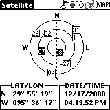
satellites. To check the satellites, select Preference
| Satellite. As I said before, once you have four satellites
you can really start using the HandyGPS. Somehow I was able to get
the HandyGPS working inside my home (although Marcus still doesn't believe
me). I guess the walls are pretty thin next to my desk. Outside,
the HandyGPS works great. I think this is a good module for hikers
or anyone that enjoys the great outdoors.
Inside the vehicle, I could get the HandyGPS to work, but it was tricky.
As a passenger, I held the HandyGPS next to the window and it worked fine;
I think using it when driving is a stretch. Although I was able to
get it working, because of the small text and street line size I think
there should be a "navigator" person that holds the HandyGPS and tells
you which way to turn. Driving under overpasses sometimes lost some
of the satellites that I was using.
One thing to remember if you have the Visor Prism is that it works very
poorly in natural sunlight. There is unfortuanately no color support
currently in the HandyGPS. The Prism does have the major benefit
of working great at night, however. Leave the daytime squinting to
the navigator. Let the person who called "Shotgun"
have the responsibility so you can keep your eyes on the road.
GPS Accuracy
When you're moving, a large circle on-screen moves to the edge of the
screen, then the screen refreshes with the circle back in the center. The top of the map is always facing North.
The circle is easy to see, and the only time it becomes a problem is in UbiGo when
the circle passes over text or icons.
This isn't a problem if you zoom in, as the circle is off to the side
of the road. Nexian claims the HandyGPS is accurate to within 25
meters, but I found the accuracy to be much better than that -- more like
10-15 meters. Although the circle was often running parallel to a
road, it seemed to touch an intersection at relatively the same time that
I did when traveling. I wonder if GPS manufacturers could have the circle "snap to" the nearest road to increase the appearance of accuracy? This would be a nifty option to have.
HandyGPS application >>